Copyright 2010 by 10News.com. All rights reserved. This material may not be published, broadcast, rewritten or redistributed.
SAN DIEGO — San Diego State University and the U.S. Navy are collaborating with Google to find where in Haiti relief supplies should be directed.
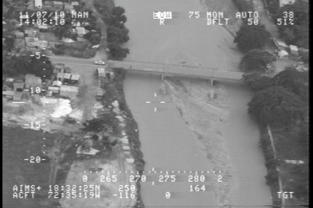
In years past, video footage shot by the Navy would have been used only by the military, Now, that same video is being shared and used by SDSU’s Visualization Laboratory in the effort to help those affected by the Haiti earthquake.
“In Haiti and Mexico and most places, they don’t have addresses that equal location, so it wouldn’t be, ‘here’s an address, go there.’ It’s like, where is it?” said Eric Frost of SDSU’s Visualization Laboratory.
To help ease the problems, images are provided by Navy crews flying P-3 Orion planes, which are normally used in anti-submarine warfare. The planes fly over the damaged areas and highly sensitive cameras capture what roads or bridges are still functional. SDSU and other groups in the project then plot the location with icons. The team determines where buildings, hospitals and refugee camps are through Google’s mapping application, and that information is provided for crews with GPS.
This kind of mapping isn’t new, as it’s been done in other disasters. But the information has been kept to a relatively select few in this particular case. It’s open to anybody who wants it or who needs it.
When disasters happen, the U.S. and other nations send in help, but non-government agencies like the Red Cross or Doctors Without Borders also respond from all over the world.
“If you’re working off the same map and the same data, you can look at it and make the right decisions because you have the data,” said Frost.
Frost credits the Navy for doing the legwork beforehand to make video sharing possible.
“We’re using the Internet to help somebody. There as are tens of thousands of people around the world,” said Frost.
If a disaster were to strike in San Diego County — whether it be an earthquake or wildfire — Frost said GPS mapping could enable residents to find escape routes or evacuation centers.


